Checking for non-preferred file/folder path names (may take a long time depending on the number of files/folders) ...
This resource contains some files/folders that have non-preferred characters in their name. Show non-conforming files/folders.
This resource contains content types with files that need to be updated to match with metadata changes. Show content type files that need updating.
| Authors: |
|
|
|---|---|---|
| Owners: |
|
This resource does not have an owner who is an active HydroShare user. Contact CUAHSI (help@cuahsi.org) for information on this resource. |
| Type: | Resource | |
| Storage: | The size of this resource is 3.6 GB | |
| Created: | Apr 11, 2021 at 4:51 p.m. (UTC) | |
| Last updated: | Aug 14, 2021 at 9:13 p.m. (UTC) (Metadata update) | |
| Published date: | Jun 12, 2021 at 2:37 a.m. (UTC) | |
| DOI: | 10.4211/hs.a2f0d5fd10f14cd189a3465f72cba6f3 | |
| Citation: | See how to cite this resource |
| Sharing Status: | Published |
|---|---|
| Views: | 4246 |
| Downloads: | 1369 |
| +1 Votes: | Be the first one to this. |
| Comments: | No comments (yet) |
Abstract
In the past several decades, field studies have shown that woody plants can access substantial volumes of water from the pores and fractures of bedrock. If, like soil moisture, rock moisture serves as an important source of plant-available water, then conceptual paradigms regarding water and carbon cycling may need to be revised to incorporate bedrock properties and processes. Here we present a lower-bound estimate of the contribution of bedrock water storage to transpiration across the continental United States using distributed, publicly available datasets. Temporal and spatial patterns of bedrock water use across the continental United States indicate that woody plants extensively and routinely access rock moisture for transpiration across diverse climates and biomes. Bedrock water access is not confined to extreme drought conditions. On an annual basis in California, the volumes of bedrock water transpiration exceed the volumes of water stored in human-made reservoirs, and woody vegetation that accesses bedrock water accounts for over 50 per cent of the aboveground carbon stocks in the state. Our findings indicate that, like soil moisture, rock moisture is a critical component of terrestrial water and carbon cycling.
CODE AVAILABLE ON GITHUB: https://github.com/erica-mccormick/widespread-bedrock-water-use
FOR MORE INFORMATION, SEE WEBPAGE: https://erica-mccormick.github.io/widespread-bedrock-water-use/
Subject Keywords
Coverage
Spatial
Temporal
| Start Date: | |
|---|---|
| End Date: |
Content
readme.md
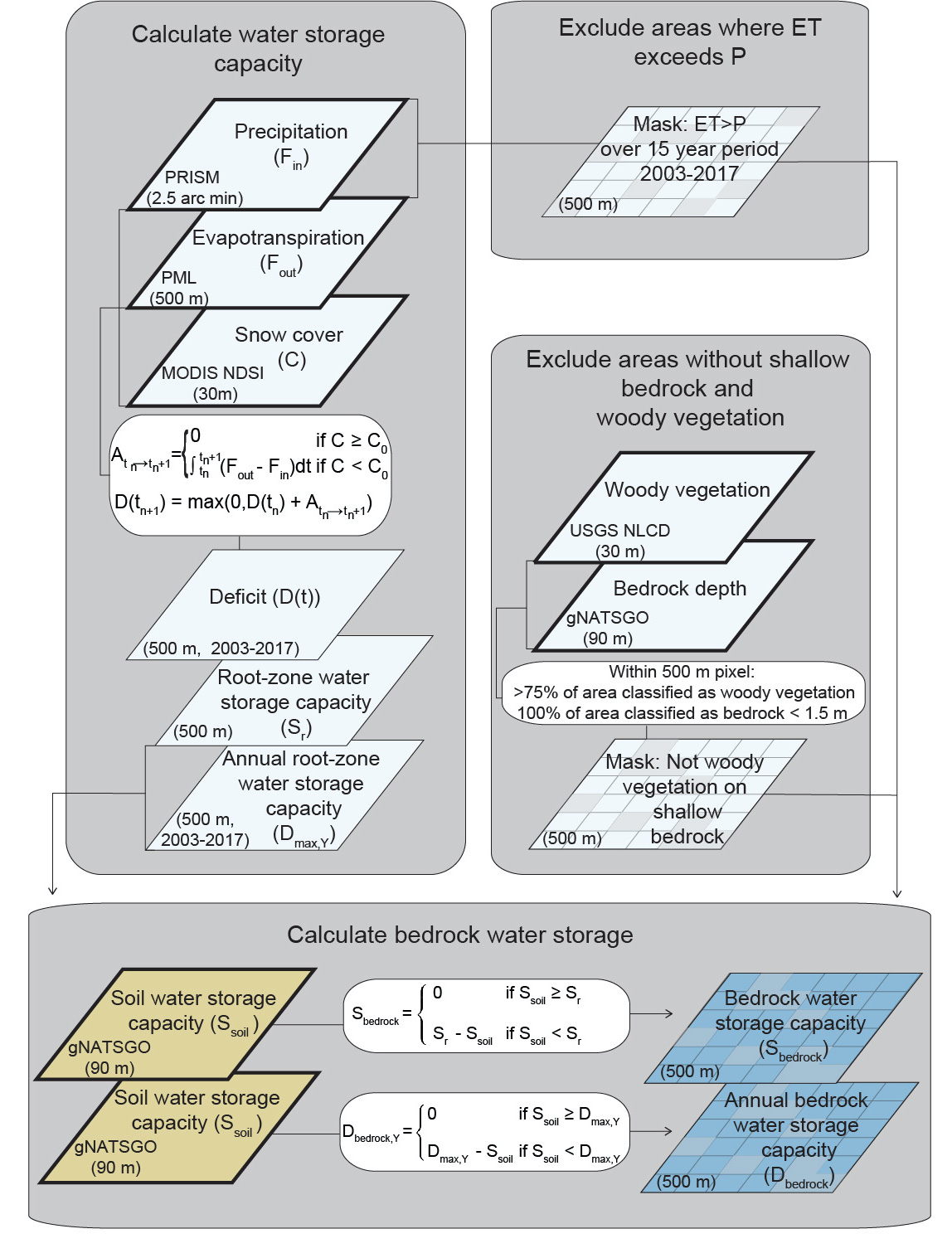
All data used in the manuscript “Evidence for widespread woody plant use of water stored in bedrock.”
See webpage for links to publicly available data resources and for more information on code and data availability.
CODE AVAILABILITY
DATA INPUTS AND PRODUCTS
FILE STRUCTURE SUMMARY
All .tifs at 500 m resolution unless otherwise noted.
├── csvs_for_plotting
│ ├── df_TWI_regression_vals.csv
│ └── df_figure4.csv
└── database_rooting_into_bedrock.csv
└── tifs.zip
├── deficits
│ ├── Dbedrock
│ │ ├── Dbedrock_2004.tif
│ │ ├── Dbedrock_2005.tif
│ │ ├── Dbedrock_2006.tif
│ │ ├── Dbedrock_2007.tif
│ │ ├── Dbedrock_2008.tif
│ │ ├── Dbedrock_2009.tif
│ │ ├── Dbedrock_2010.tif
│ │ ├── Dbedrock_2011.tif
│ │ ├── Dbedrock_2012.tif
│ │ ├── Dbedrock_2013.tif
│ │ ├── Dbedrock_2014.tif
│ │ ├── Dbedrock_2015.tif
│ │ ├── Dbedrock_2016.tif
│ │ ├── Dbedrock_2017.tif
│ │ └── Dbedrock_count_years_gt0.tif #years of positive Dbedrock used in Figure 1
│ ├── Dbedrock_no_masking
│ │ ├── Dbedrock_2004_nomask.tif
│ │ ├── Dbedrock_2005_nomask.tif
│ │ ├── Dbedrock_2006_nomask.tif
│ │ ├── Dbedrock_2007_nomask.tif
│ │ ├── Dbedrock_2008_nomask.tif
│ │ ├── Dbedrock_2009_nomask.tif
│ │ ├── Dbedrock_2010_nomask.tif
│ │ ├── Dbedrock_2011_nomask.tif
│ │ ├── Dbedrock_2012_nomask.tif
│ │ ├── Dbedrock_2013_nomask.tif
│ │ ├── Dbedrock_2014_nomask.tif
│ │ ├── Dbedrock_2015_nomask.tif
│ │ ├── Dbedrock_2016_nomask.tif
│ │ └── Dbedrock_2017_nomask.tif
│ ├── Sbedrock.tif
│ ├── Sbedrock_dividedby_Sr.tif
│ └── Sr.tif
├── masks
│ ├── masks_all_combined.tif
│ ├── mask_shallowBedrock.tif
│ └── mask_woodyVeg.tif
│ └── mask_ET_gt_P.tif
└── products_used
├── MAP_PRISM_2003_2017.tif # mean annual precipitation (mm) calculated using PRISM daily precip (2003 to 2017)
└── gNATSGO
├── Ssoil_500m.tif
├── densic_bedrock_depth_90m.tiff
├── lithic_bedrock_depth_90m.tiff
└── paralithic_bedrock_depth_90m.tiff
Related Resources
| This resource is described by | https://erica-mccormick.github.io/widespread-bedrock-water-use/ |
| The content of this resource can be executed by | http://doi.org/10.5281/zenodo.4904037 and https://github.com/erica-mccormick/widespread-bedrock-water-use |
| This resource is referenced by | McCormick, E., Dralle, D.N,, Hahm, W.J., Tune, A., Schmidt, L., Chadwick, K.D., Rempe, D. (2021). Accepted, Nature. http://doi.org/10.1038/s41586-021-03761-3 |
How to Cite
This resource is shared under the Creative Commons Attribution CC BY.
http://creativecommons.org/licenses/by/4.0/
Comments
There are currently no comments
New Comment